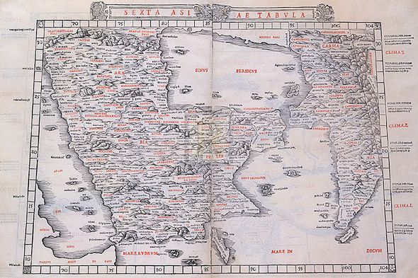
Claudius Ptolemy Hand Numbered Limited Edition Print on Paper :"Sexta Asiae Tabula, 1511"
Title: Sexta Asiae Tabula, 1511
Dimensions (W x H ): Paper Size: 24 x 16 in | Image Size: 24 x 16 in
Edition | Medium: Each print is hand numbered, accompanied by a certificate signed by the Master Printer and is numbered to match the print. The editions are limited to 1880 copies. |
This Gouttelette print on paper is published with light-fast inks to BS1006 Standard onto acid-free calcium carbonate buffered stock, mould-made from 100% cotton and sourced from environmentally conscious paper suppliers. This product is exclusive to Rosenstiels.
About the Art: Superior Edition
About the Artist:
The eminent scholar Claudius Ptolemaeus lived between approximately 83 and 161 AD and is generally known in English as “Ptolemy”.
A Greek mathematician, astrologer, astronomer and geographer, Ptolemy was probably born in a town called Ptolemais of Hermias in Roman Egypt. He died in Alexandria.
Ptolemy was the author of a number of scientific treatises, of which the most important two were his work on astronomy, now known as the Almagest, and his introduction to the geographical knowledge of the Greco-Roman world, the Geographia. In his books, Ptolemy assembled and codified his predecessors’ cartographic theories, in which he was particularly indebted to those of Marinus of Tyre, who worked around AD110. Geographia was published in 8 volumes and apparently illustrated with a world map, 26 regional maps and a wide number of smaller maps. Although the text to this great work survived, it does not appear to have been accompanied by any of the maps; the oldest of Ptolemy’s maps known today derives from around the 12th Century. There is therefore currently no means of knowing whether the Ptolemy maps, which form the basis of world cartography, were in fact drawn by him or were simply the interpretations of later cartographers interpreting Ptolemy’s text.
Although the fall of the Roman Empire generally led to a loss of much acquired knowledge and learning to the west of Europe, Ptolemy’s work remained very influential on Islamic thought, and to the east. In Europe, a revival of interest in Ptolemy’s Geographia occurred after the year 1400, when Greek manuscript copies were brought by scholars from Constantinople to Italy and thereafter widely translated. The translations coincided with the invention of moveable type printing by Gutenberg in about 1450, which made possible the publication in quantity of printed books.
Publication of Ptolemy’s maps continued throughout the 15th and 16th centuries under the names of many other publishers until they were gradually replaced by more contemporary and up to date maps. Many editions of Geographia were published after 1477, including the famous edition by Leinhart Holle in Ulm in 1482, Bernardus Sylvanus’s 1511 edition, issued in Venice, and in 1522 an edition by Laurent Fries, in Strassburg.
Ptolemy is undoubtedly the Founding Father of European mapmaking; he also produced an interesting treatise on astrology known as the Tetrabiblos (“Four Books”).


